Entries in Archaeology (14)

Friday
Oct202023

The Origin of Henge Monuments

The following is a comment I posted on mathstodon.xyz:

My personal theory for the origin of henge monuments and stone circles is that they evolved from the rituals performed by seminomadic people during the mesolithic when they returned to their summer camp site in the spring (or to their winter camp site in the autumn). All they find left of their previous home is the circle of wooden posts which held up the walls and the circular drip trench outside them. They repair the posts where necessary and then construct the framework of a conical roof above the posts and cover it and the walls with hides. They also clear out any foliage from the drip trench and redig it where necessary. They then go around and tend to the graves of those who died on previous visits to that camp. At the end of the season they dismantle the roof and pack up the hides and take them with them to their alternate camp site. After thousands of years of this, the people settle down at a permanent camp site, but they keep up the rituals ("because that is what we've always done!"). After a few more thousand years of rivalry between neighbouring families you end up with something like Stonehenge.

Although I haven't seen this theory mentioned anywhere, it does seem to explain several of the key features of henge monuments: the circle of wooden posts (stone posts only came later); the circular ditch outside the posts; the association with graves; and the association with processional ways.

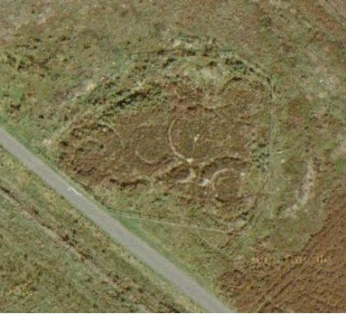
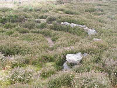
This idea was partly inspired by memories of a childhood visits to an excavated Iron Age famstead on the North York Moors, near where we lived. The farmstead consisted of three or four round-houses of which only the base of the stone walls and central hearth-stones remained. The excavators had scooped out the drip-trenches around the walls, leaving only the entry path in front of the door-ways. As a child, I was fascinated by the thought that I was running in and out of the door-ways in the same way that children must have done two thousand years before.

Tuesday
Oct112011

Wayland's Smithy

Wayland's Smithy, a Neolithic chambered tomb on the Ridgway in south Oxfordshire.

This image is a panorama that I constructed from photos originally taken by my father John Brelstaff on 2006-10-23.

Sunday
Jan112009

If Google did Archaeology...

A thought that came to me while watching Phil Harding knapping flint on television a few months back:

If Google did archaeology they would scan all of the stones and soil particles from an archaeological site, identify each fragment of flint and produce a 3D software model of it, and then use software to reconstruct the original lumps of flint, and the sequence in which the fragments were taken off.

Sunday
Dec072008

Iron Age Farmstead on Percy Cross Rigg

On the hills above Guisborough, the town where I grew up, Google Maps shows these circular structures on Percy Cross Rigg, beside the Kildale Road.  In the 1960's an archaeological dig was carried out and revealed the circles to be the bases of round houses and that the site was probably an Iron Age farmstead.  The following is a summary of the dig taken from Appendix M of this report on an archaeological site on a golf course at Normanton in West Yorkshire:

Cropmark revealed a sub-rectangular enclosure 100m in length located near the crest of a ridge at 280m OD. Half way along one side of the enclosure an area 50m square was excavated to reveal the platforms and remains of five circular huts which could be divided into three phases of occupation. The earliest phase consisted of two poorly preserved roundhouse structures defined by drip gullies and post holes. The second phase comprised a single hut as above. The latest phase of occupation consisted of two substantial roundhouses 7m in diameter terraced into the hillside. Both were of dry stone wall construction and had the remains of a paved floor and central hearth in situ, surrounded by substantial drainage gullies. A saddle quern, a beehive quern and a fragment of jet bracelet were recovered from the site along with a small amount of local hand made coarse pottery.

Percy Rigg has been interpreted as a small enclosed farmstead. A part from the two different querns which may indicate a long life to the settlement there was no further evidence of cereal processing or storage on the site. Despite further limited trenching within the enclosure no other archaeological features were located.

The pottery assemblage and querns date the beginnings of the settlement to the 4th century BC.

We visited the site on a family walk one weekend when I was about 7 years old.  It must have been soon after the excavations had completed because the circular bases were laid bare.  Around the outside of each base was a circular drainage ditch (to collect water that has run off the conical roof).  On the inner side of each ditch were the lower courses of circular dry-stone walls.  The floors of some of the houses were paved with irregular shaped sandstone slabs, and at the centre of each house was a large flat sandstone hearth stone. 

For a child, it was fascinating to see the outlines of ancient houses explicitly layed out on the ground like that.  You could play games running from house to house, in and out of the doors and round the fireplaces, just as children must have done two thousand years earlier.

Indeed, I was so fascinated that, the following day, I took several of my younger friends on an expedition to revisit the place.  To find the way I took a map with me, a fact which seemed to impress some adult hikers who were also visiting the site.  Flushed with the success of finding it, I then led my friends on to look for some other archaeological site marked on the map.  However, we got lost in some woods and, rather than turn back, I made the decision to go down to the nearest road and walk back to Guisborough along the roads, via Kildale, Easby and Great Ayton.  We didn't get home until the early evening, after walking about 10 miles, and having been out all day.  Our parents seemed very relieved to see us back.

A few years later the excavations were covered over, the paved floors were hidden and the ditches filled in.  Now all that is visible is the tops of the circular dry-stone walls poking up through the heather.

Wednesday
Sep172008

Pre-Columbian Mountaineering

From Wikipedia page on World Altitude Records (mountaineering):

European exploration of the Himalaya began in earnest during the mid-19th century, and the earliest people known to have climbed in the range were surveyors of the Great Trigonometric Survey. During the 1850s and 1860s they climbed dozens of peaks of over 6,100 m (20,000 ft) and several of over 6,400 m (21,000 ft) in order to make observations, and it was during this period that claims to have ascended the highest point yet reached by man began to be made.
Most of these early claims have now been rendered redundant by the discovery of the bodies of three children at the 6,739 m (22,110 ft) summit of Llullaillaco in South America: Inca sacrifices dated to around AD 1500.  There is no direct evidence that the Incas reached higher points, but the discovery of the skeleton of a guanaco on the summit ridge of Aconcagua (6,962 m, 22,841 ft) suggests that they also climbed on that mountain, and the possibility of Pre-Columbian ascents of South America's highest peak cannot be ruled out.