Wednesday
Feb252009
Cave Paintings as Graffiti by Teenage Boys
Here is an interesting post by Pascal Boyer discussing The Nature of Paleolithic Art by Russell Dale Guthrie.
Here is an interesting post by Pascal Boyer discussing The Nature of Paleolithic Art by Russell Dale Guthrie.
In the late 1970's I studied biochemistry at Leeds University and one of the textbooks we used was Morrison and Boyd's Organic Chemistry. The then current edition was a smart black, chunky paperback, and I remember it fondly for its nice diagrams and clear explanations (I already liked the subject of organic chemistry for its neat logical, almost computer program-like structure). Little did I know that this book had been part of a little revolution in the way organic chemistry was taught. The story of this revolution, and the origin of the Gutenberg Method, is told here in two articles by Robert T. Morrison and Frank L. Lambert.
A girl wearing the uniform of the Blessed Hugh Faringdon School, talking to a girl from John Madejski Academy:
And there's this teacher who tries to teach us science in a pirate voice. He's so cool.
I really want to see this. So much so, that I'm thinking of offering myself to BHFS as a volunteer to help out in science lessons.
A maths teacher, just after handing each student a calculator:
Albert! Stop typing BOOBS on your calculator!
I presume this was a reference to the number 80085.
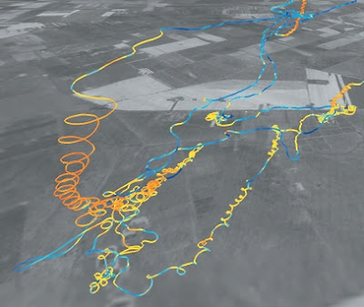
An oblique view of the flight-track of a peregrine falcon taken from the paper "Comparing bird and human soaring strategies" by Zsuzsa Akos, Mate Nagy, and Tamas Vicsek (Proc Natl Acad Sci USA, 105, 4139-4143, 2008. arXiv:0902.0312v1 [physics.bio-ph]). The altitude and location of the bird were tracked by fitting it with a miniaturized GPS device. The red and yellow parts of the track correspond to when the bird was climbing (mostly on thermals), and the blue parts to when the bird was falling (gliding). The grey background is a satellite image of the terrain.
 Tristram Brelstaff